Early county maps
The earliest county map to show Carden is that first published by John Speed in 1610. His maps were copied and reissued over the next century and more. His survey was clearly influenced by Saxton’s earlier map of 1577, although it is not derived from it; his scale is about 1:175000. It has been thought that the symbol used to denote a township is a church, but as most Cheshire townships do not possess churches or chapels, this cannot be the case. As a local man (Speed was born at Farndon), it is unlikely that he was misled into believing that all townships possessed churches. The symbol may in fact depict a manor house, and this what is used to depict Carden.
Burdett’s map (1777)
The earliest map to show Cheshire in any detail was that published by Peter Burdett in 1777. It depicts the county at a scale of one inch to one mile (1:63360) but it is evident that the survey was patchy and lacking in reliable detail away from centres of habitation and main roads, particularly in its depiction of minor roads. However, as a cartographic source it contains much useful information about the general road layout, locations (but not extents) of heaths and commons, positions of churches and so on.
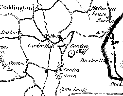 It is difficult to interpret Burdett’s map in the area
around Carden: because the Wrexham-Nantwich turnpike had not yet
been built, all the roads in this area are minor and are
consequently only sketchily drawn. One change is in the alignment
of the road from Coddington towards Clutton: Burdett shows it
without a kink at the southern end, a line that is preserved in
hedgerows. The present road running southwards at the western
foot of Carden Cliff does not appear to be shown, the road being
a more westerly line preserved as tracks and public rights-of-way
on later maps. Carden Green is represented as stretching north as
well as south from the junction of this road with the road from
Stretton Mill. The Mill is marked, as is Carden Brook.
It is difficult to interpret Burdett’s map in the area
around Carden: because the Wrexham-Nantwich turnpike had not yet
been built, all the roads in this area are minor and are
consequently only sketchily drawn. One change is in the alignment
of the road from Coddington towards Clutton: Burdett shows it
without a kink at the southern end, a line that is preserved in
hedgerows. The present road running southwards at the western
foot of Carden Cliff does not appear to be shown, the road being
a more westerly line preserved as tracks and public rights-of-way
on later maps. Carden Green is represented as stretching north as
well as south from the junction of this road with the road from
Stretton Mill. The Mill is marked, as is Carden Brook.
There is no indication of a Park at Carden: the Hall is named, but there are no signs of an avenue leading south from it, a feature that Burdett usually plots. This perhaps means that the creation of the Park can be placed in the closing decades of the eighteenth century or the opening decades of the nineteenth, perhaps by William Leche.
Greenwood’s map (1819)
Charles Greenwood’s map, based on an original survey in the year of publication, is the first accurate large-scale map of the county. At a scale of 1:64366 it is slightly smaller than Burdett’s, but the depiction of roads, houses, boundaries, streams and so on is greatly superior to his. The design is very similar to the much later Ordnance Survey one-inch first series.
The Park is shown for the first time, slightly smaller than on later maps. This is largely because the Farndon to Nantwich Turnpike road had not yet been built, and the older road followed a slightly more southerly course. To the south of the Park, the hamlet of Carden Green clusters between what is now Home Farm to the north and Lower Carden Hall to the south. This map is the first evidence for the existence of Carden Park as a landscape unit.
Swire & Hutchings’ map (1828/9)
This map, at a scale of 1:84400, shows Carden Hall surrounded by parkland, although the extent is much smaller than that shown on later maps. The southern limit of the park at this date was immediately to the north of Home Farm. The Hall is shown, with approach roads to the north and west, while to the south is an avenue. Along the western side of Carden Brook is a strip of woodland, stretching down to Stretton Mill.
The parish boundary between Farndon and Tilston is shown in a different location from the boundary that exists today. The present boundary runs eastwards towards Carden Brook, turns north along the brook and then resumes an easterly direction through Carden Hall. Swire & Hutchings show it turning to the north somewhat west of Carden Brook and running along the north side of the Farndon-Broxton road before turning north about 200 m east of Clutton Hall Farm. It would be easy to write this off as inaccurate surveying, but the boundaries given are very specific, give indications of small changes and were probably drawn before boundary changes in the late 1820s. They were possibly based on those shown on the larger-scale survey by Greenwood (although a notable error is the contraction of King’s Marsh to an area entirely south of the Turnpike road).
Bryant’s map (1831)
The scale of Bryant’s map is 1:50688, permitting a considerable expansion of detail over Swire & Hutchings’. Carden Park appears as a much more extensive property on this map than on Swire and Hutchings’, which means either that the parkland had expanded considerably during the intervening two years or that the surveyors used different criteria for showing the extent of parkland. The woodland west of Carden Brook has gone and the parkland extends beyond it, the ornamental lake now stretches to the south of the Barton approach road and the southern boundary of the park is almost on the line of the Stretton Mill-Lower Carden road.
Some of these alterations can be attributed to inaccurate surveying. The size and position of the lake are demonstrably incorrect: it is placed too close to Carden Brook, and its extension to the south of the Barton approach road is ruled out by the continuation of ridge-and-furrow earthworks across this area on the 1947 aerial photographs. The complete lack of woodland west of the Brook is also wrong, as woodland is still shown in places on the 1839 Tithe Map of Stretton. The map also ignores the part of Clutton village south of the Farndon-Broxton road, recording this as parkland.
It is therefore clear that there was some sloppiness in the surveying of Bryant’s map, and that the differences between his and Swire and Hutchings’ map cannot always be taken as evidence for changes in the landscape in the two years between them. On the other hand, where no evidence exists to show whether Bryant’s survey is accurate, we cannot dismiss it out of hand. Certainly, his depiction of parish boundaries is close to the modern lines, following boundary changes in the late 1820s, and are frequently different from those on Swire & Hutchings’ map.
Because of the large scale, Bryant was able to name a number of minor places that are not recorded individually at an earlier date. To the northeast of the park, the pond south of Clutton Hall Farm (which is not named) is labelled Shay Green Pit (for Shaw Green Pit); part of the woodland to the south is called Clutton Cover (for Clutton Covert). Carden Cliff is named, as is Carden Farm, now Home Farm, on the Carden estate.
The Ordnance Survey
The first edition Ordnance Survey one-inch (1:63,360) map was published in 1833 but based on survey work undertaken between 1817 and 1819 and again between 1829 and 1831. It shows Carden Hall straddling the township boundary between Carden and Clutton. The pattern of roads is similar to that shown on the Tithe map, with the additional road running south from Clutton into what is now the Carden estate. No parkland is shown, and neither Carden Lodge nor Clutton Lodge has yet been built. The north-south approach road to the Hall via these lodges is not shown, the only approach being from the west, between Barton and Clutton.
A number of very minor names appear for the first time on this map, including the Hall, Carden Cliff, Bowling Alley House and Golburn Wood, the last two not previously recorded.