The ‘Wall of Severus’
 One of the more startling claims of The
Keys to Avalon: the true location of Arthur’s Kingdom revealed (Blake, S & Lloyd, S; Shaftesbury: Element,
2000) is that what has been known for the past thousand years and more as
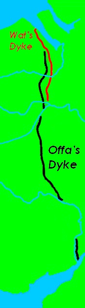
‘Offa’s Dyke’ was in fact built by Roman armies during the reign of
Septimius Severus (Emperor 197-211). They use literary texts and, as a ‘stop
press’, a radiocarbon date for Wat’s Dyke, whose relevance is not
immediately apparent. Interestingly, they hardly use archaeological evidence.
One of the more startling claims of The
Keys to Avalon: the true location of Arthur’s Kingdom revealed (Blake, S & Lloyd, S; Shaftesbury: Element,
2000) is that what has been known for the past thousand years and more as
‘Offa’s Dyke’ was in fact built by Roman armies during the reign of
Septimius Severus (Emperor 197-211). They use literary texts and, as a ‘stop
press’, a radiocarbon date for Wat’s Dyke, whose relevance is not
immediately apparent. Interestingly, they hardly use archaeological evidence.
On what do they base their claim? The argument
begins in their redesigned geography of Britannia/Ynys Prydein.
They locate the Saxon invasion in Gwent, which they derive from the Ceint
of the Historia Brittonum in contrast to the accepted derivation Venta>Guent>Gwent.
They then take the Historia’s statement (Chapter 38) that illis
regiones quae sunt in aquilone iuxta murum qui uocatur guaul ‘those
regions which are in the north, next to the wall called Gwawl’ with the
earlier statement (Chapter 23) seuerus...
murum et aggerem a mari usque ad mare per latitudinem brittanniae, id est per
cxxxii milia passuum deduxit et uocatur brittannico sermone guaul ‘Severus...
built a wall and embankment from sea to sea across the width of Britain, that is
for 132 miles, and it is called Gwawl in the British language’.
Turning
then to the Historia Augusta, a fourth-century compilation of Lives of
various emperors from Hadrian to the later third century, they make the
astounding claim that “this one text alone forms the basis of our knowledge
of the names of the Romans who built the Hadrian and Antonine Walls”. This
does immense disservice to many years of archaeological investigation of the
Walls, but no matter. They are more impressed with the statement in the Historia
Augusta’s Life of Severus (xviii.2) that brittanniam, quod maximum eius
imperii decus est, muro per transuersam insulam ducto utrimque ad finem oceani
muniuit ‘he fortified Britain, which is a great ornament of his reign,
with a wall led across the breath of the island to the edge of the Ocean on both
sides.’ Again, at xxii.1, the Life mentions murum aut uallum... in
Brittannia ‘a wall or rampart... in Britain.’
They
attempt to translate Latin insula as ‘realm’, which is a completely
unattested use of the word in a text written in the Mediterranean world, let
alone Britain, but once again, let us pass over that. They criticise the
consensus view that the documentary references to a Wall of Severus merely refer
to a refurbishment of Hadrian’s Wall on the grounds that “the texts
clearly state that there was a third Roman wall in the British Isles”.
Once again, there is a problem that they gloss over: the is not one single text
that states that there were three walls in Britain.
However,
they draw a number of conclusions from their reading of the texts:
- Septimius
Severus built a defensive earthwork
- It
went from sea to sea
- It
was 132 milia passuum long
- It
separated Deifr and Alban
Having
established this, they then turn to the Brut for evidence about the
location of the Wall. They take its statement that Oswald, King of Northumbria,
fought Penda, King of Mercia, at Maes Nafawl or Heavenfield, near
Severus’s wall. This derives from Geoffrey of Monmouth (HRB xii.10),
where the mistake of confusing the Battle of Heavenfield with the Battle of Maserfelth
is first made. They do not spot this and instead castigate those who “have
located this battle near Hexham... because of the reference to ‘the wall’,
despite the fact that no evidence exists to back up this claim”. Evidently
they have not read Bede (Historia Ecclesiastica iii.2),
where hefenfelth… hagustaldensis ecclesiae, quae non longe abest, ‘Hefenfelth… the church of Hexham, which is not far
away’, writing less than a century after the event. But again, never mind. How
do they pursue their quest for the true geography of Britannia/Ynys
Prydein? They accept Geoffrey’s confusion and identify the Battle of
Heavenfield, as a result of which Oswald became King of Northumbria, with the
Battle of Maserfelth, at which he lost his life. They then use the
twelfth-century Vita Sci Oswaldi to show that this battle was near
Oswestry, Shropshire. A major earthwork frontier passes close to Oswestery:
Offa’s Dyke. This, they argue, is Gwawl, the ‘Wall of Severus’.
They make a great deal of the length of the Wall
of Severus given by Late Roman and Insular writers, where the figure cxxxii
(132) milia passuum (Roman miles of 1,480 m) is generally given. This is
a little over 195 km (a little over 121 statute miles); Offa’s Dyke is around
192 km long (a little over 119 statute miles). The coincidence of length is
impressive, it has to be said, even though there are only 130 km (81 statute
miles) of earthwork. But what about the name?
Offa’s Dyke is first attributed to the King of
Mercia (757-796) by Asser (Vita Regis Ælfredi Chapter 14), where it is
said that fuit
in mercia moderno tempore quidam strenuus atque uniuersis circa se regibus et
regionibus finitimis formidolosus rex, nomine offa, qui uallum magnum inter
britanniam atque merciam de mari usque ad mare fieri imperauit ‘In recent
times, there was a certain king in Mercia, vigorous and terrifying to all the
kings and regions around him, Offa by name, who ordered a great wall to be built
between Wales and Mercia, from sea to sea’. However, Blake and Lloyd are
worried by “how it was that the Saxons managed to build such a major
structure whilst under constant attack from the Welsh and how a people with no
history of building huge earthen banks... had the engineering skill to undertake
such a vast project”. We can pass over in silence the Wansdyke and
numerous other Early Saxon defensive earthworks and ignore the evidence (such as
the Annales Cambrię)
that suggests that Offa was the aggressor, who constantly harried the Welsh.
But
what of the “Roman artefacts... found within the Dyke”? This is an
archaeological question, and one that they do not pursue. They evidently do not
understand the concepts of the terminus post quem – the archaeological
principle that states that no deposit can be older than the date of the most
recent object found within it – and residuality – the idea that objects can
turn up in deposits of much more recent date. These are important points, as
they are crucial to understanding the radiocarbon evidence.
Having
established the coincidence of length between Offa’s Dyke and the ‘Wall of
Severus’/Gwawl, Blake and Lloyd start looking for documentary
confirmation that the two are one and the same. They find it in an
eleventh-century Irish translation of the Historia Brittonum called Lebor
Bretnach (not “an Irish manuscript compiled in the eleventh
century”, as five manuscripts are known, ranging from an eleventh-century
fragment down to full texts of the fifteenth and sixteenth centuries). In the
Irish translation of Chapter 23 of the Historia, Chapter 17 of Lebor
Bretnach has Seuerus in treas ri tainic i mBretnaib. Is leis doronad clad
Saxan a n-agaig na mBarbarda .i. Cruithneach. Da mile xxx ar c cemann ana fad, 7
is e ainm an claide sin la Bretnu Guaul, ‘The third king who came to
Britain was Severus. He made the Saxon trench against the barbarians, i.e.
Picts. It is 130 miles long and the name of the trench in British is Guaul’.
Where the translator of Lebor Bretnach (an Irish scholar called Gilla
Coemghin) got the description of Gwawl as being Saxon is unclear, but
Blake and Lloyd see this as an important confirmation of their revised toponymy.
They have no problem with Picts bordering Offa’s Dyke, as they have already
relocated them in North Wales (as the Gwyddyl Ffichti of Powys, mentioned
only in one of the genealogies collected in the fourteenth-century Jesus
College, Oxford, MS 20).
However,
Gilla Coemghin continues 7 roforcongair clod aili do denum a n-agaid
Gaedeal 7 Cruithnech .i. clad na muice, ‘and he ordered another
trench to be made against the Scots and the Picts, i.e. the Trench of the
Swine’. This is interesting, and Blake and Lloyd do not quote it; Gilla
Coemghin understood there to be two walls in Britain, so he corrects the Historia
Brittonum and attributes the second wall to Severus, too. Whereas the first
was called Guaul, the second is known as the Trench of the Swine. A
variant of this name (Swine’s Dike) was recorded by the early eighteenth-century
antiquary Horsley as a local name near Falkirk for the Antonine Wall. It is
important to note that here Cruithneach, ‘The Picts’, are associated
not with North Wales, but with Swine’s Dike in central Scotland; we may assume
that Gilla Coemghin believed that the same Picts were to be associated with Guaul.
Notwithstanding
this, Blake and Lloyd consider the case more-or-less proven at this point. They
believe that Gilla Coemghin specified that the ‘Wall of Severus’ was clad
Saxan, ‘the Saxon trench’ because he knew of Asser’s attribution of it
to Offa over a century earlier. This does not seem very likely, as Asser’s Vita
Regis Ælfredi does not seem to have been widely known. Still, there is “a
stone inscribed to him that was found in Caernarfon, and it has also been
suggested that he rebuilt the walls of Chester”, which they take as
evidence that the emperor was in Wales at some point.
Finally,
how did Asser come to misattribute the ‘Wall of Severus’ to Offa? They note
that there are several placenames associated with both Offa’s and Wat’s
Dykes that contain the name Offa. This is an error, they suggest, for
Hengist’s cousin Ossa, “whose name is wiritten in many manuscripts as
Offa because of the similar appearance of the letters s and f in
old manuscripts”, although they do not suggest how palaeography might
explain changes in placenames. There is a problem, predictably. In Geoffrey of
Monmouth, following the Historia Brittonum, the names of the two
relatives of Hengist given land near Guaul are Octha and Ebissa; the Brut
changes Ebissa to Ossa Gyllefawr, identified with the grandfather of Ida
of Northumbria in the Historia Brittonum (Chapter 57). This is one of
numerous changes made by the Brut to Geoffrey’s text, which derives
much of its narrative from the Historia Brittonum; these changes are
generally to bring the Brut into line with vernacular traditions.
This
is the evidence assembled by Blake and Lloyd in their reassessment of Offa’s
Dyke and their attempt to show that it was built by the Roman emperor Septimius
Severus. Their evidence consists almost entirely of documentary discussion, much
of it using dubious sources, many of which are presenting information at second
or third hand. The various holes in the treatment of the evidence have been
pointed out, but it is necessary to go further, to look first at the documents,
then the archaeology and finally the historical probabilities and possibilities.
The case for renaming Offa’s Dyke turns out not just to be weak, but wrong in
the final analysis.